
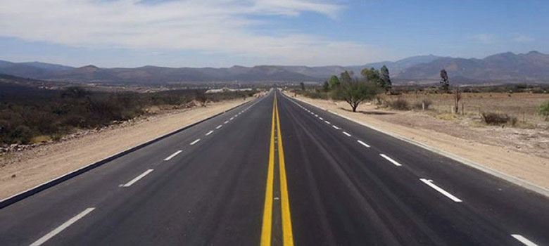
Road marking system
Road markings are a form of signaling to guide and control traffic to improve safety and traffic flow. Road markings are divided into two types: horizontal and vertical.
Road markings can be used independently or in combination with road signs or traffic lights.
In the case of a place with both road markings and signs, drivers must comply with the control of the signs.
Road markings with a design speed ≤60km/h
1 – Horizontal line
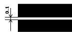
Line 1-1: Solid, white line, 10 cm wide, used to separate 2 lines of traffic going in opposite directions, to determine the boundary of the prohibited road section, the boundary of the parking area, the boundary of the lane in a dangerous position. Vehicles are not allowed to cross this line.
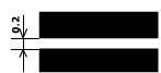
Line 1-2: Solid, white line, 20 cm wide, used to determine the edge of the road section on the road axis. Vehicles are allowed to cross or cross the line when necessary.
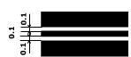
Line 1-3: Double line (2 continuous lines) in white, with equal width and 10 cm, 10 cm apart, used to separate 2 lines of traffic going in opposite directions on roads with 4 lanes or more. Vehicles are not allowed to cross the line.
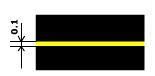
Line 1-4: Is a continuous yellow line, 10 cm wide, to identify areas where stopping and parking are prohibited.
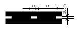
Line 1.5: Is a broken white line, 10 cm wide, ratio L1:L2 = 1:3. The line is used to separate 2 traffic streams from 2 opposite directions on roads with 2 or 3 lanes. Determine the lane boundary when there are 2 or more lanes running in one direction.
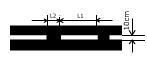
Line 1-6: Is a broken white line, 10 cm wide. Ratio L1:L2 = 3:1, used to signal approaching line 1-1 or 1-11, to separate traffic streams going in the opposite direction or the same direction.
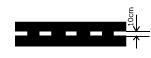
Line 1-7: Is a broken white line, 0.1 m wide, the distance between the two lines is 0.5 m. The line is drawn along the curve along the direction of traffic at the intersection when driving, it is necessary to have a general orientation to ensure safety when passing the intersection.
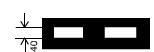
Line 1-8: Is a white broken line 0.4m wide. The line is used to turn to identify the lane boundary for vehicles to increase speed or decrease speed (called changing to the lane) and the main lane of the traffic section.
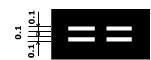
Line 1-9: Is a double line (two lines), broken, parallel, white, 0.1m wide and 0.1m apart.
The turning line identifies the reserve lane boundary on which the direction of traffic can change either forward or reverse. The change in direction is controlled by green and red light signals placed on the lane.
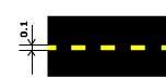
Line 1-10: Is a yellow broken line. The line identifies the location or area where parking is prohibited.
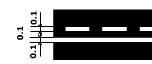
Line 1-11: Two parallel lines (double lines) in white, one broken line and one solid line.
The line is used to separate the flow of traffic in two opposite directions on roads with two or three lanes. Drivers are allowed to cross the line from the side with the broken line.
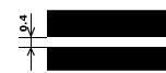
Line 1.12: The line indicates the position where vehicles must stop when there is a sign number 122 “Stop” or when there is a red light. This line is drawn across the entire road in the direction of traffic. In the case where there is no sign 122 or no light or driver, line 1.12 is not valid.
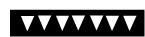
Line 1.13: A white isosceles triangle line indicating the position where drivers must stop to give way to other vehicles on the priority road.
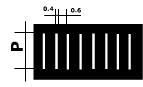
Line 1-14: A “zebra stripe” line consisting of white lines parallel to the center of the road, 40 cm wide, 60 cm apart. Lines indicating where pedestrians cross the road.
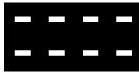
Lines 1-15: The line consists of 2 parallel broken lines, 1.8 meters apart, with the length, width and distance between the lines of the broken lines being equal and equal to 40 cm.
The line determines the position where bicycles cross the road of motor vehicles. Bicycles must give way to motor vehicles running on the road crossing the bicycle lane.
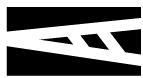
Line 1.16.1: White “zebra”, determines the island dividing the traffic flows in opposite directions.
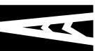
Line 1.16.2: The line determines the island dividing the traffic flows in the same direction. At this point, the traffic flows in the same direction are divided into many different lines (lanes).
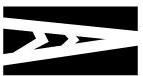
Line 1.16.3: The island merging the traffic flows. At this point, the traffic flows in the same direction merge together.
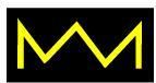
Line 1.17: Yellow wavy line indicating the stopping position of vehicles of all means of transport. According to the designated turning route or the gathering place of taxis, it is forbidden to stop or park any type of vehicle in both directions and 15cm away from the line.
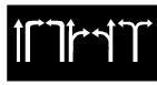
Line 1.18: White indicates the permitted directions of the lanes at the intersection. Drivers must follow the arrow indicating the direction when encountering this sign.
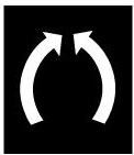
Line 1.19: White line, the line that determines the approaching narrowing position of the roadway, notifies the driver that the number of lanes in the direction of the arrow is reduced and the driver must slowly change lanes in the direction of the arrow.
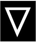
Line 1.20: White, indicating that you are approaching line 113 and sign 108, the distance to line 1.13 is 2-2.5m from the center of the road (highways can be larger), drivers are allowed to run over line 1.13 without stopping.
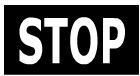
Line 1.21: White “Stop” letter, indicating that you are approaching the stopping position of line 1.12 and sign 122. Line 1.21 is 2-2.5m from the stop line.
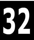
Line 1.22: Is a road number line, drawn on the national highway and drawn directly on the road surface
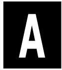
Line 1.23: Is a lane line for large passenger cars running along the designated turning route.
2 – Vertical lines
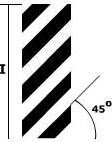
Line 2.1: Determines the straight parts of traffic works such as bridge piers, overpasses, etc. to indicate dangerous places for passing vehicles.
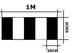
Line 2.2: Is a vertical alternating black and white line, determining the bottom edge of bridges and overpasses.
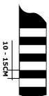
Line 2.3: Is a horizontal alternating black and white line. Drawn around round posts placed on safety islands or on median strips and other places.
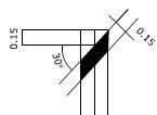
Line 2.4: Is a black diagonal line forming a 30o angle with the horizontal plane, 0.15m wide, used to draw on signal posts, barrier posts, and markers.
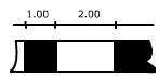
Line 2.5: Drawn on fences with barriers, small-radius roundabouts, roads higher than the surrounding area, and slopes down to other dangerous places.

Line 2.6: Drawn on the walls of barriers placed in especially dangerous places.
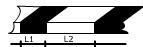
Line 2.7: Drawn on the walls of sidewalks in dangerous places, along the walls of safety islands.